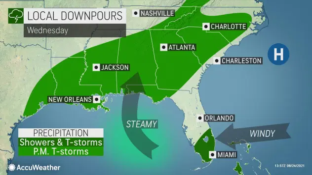
As a storm rolls westward from the Atlantic, some people in the southeastern United States can expect a break from extreme heat by way of drenching thunderstorms over the next few days, but some of the same locations and others can be slammed by flash flooding and gusty winds from storms that become stronger,�AccuWeather�meteorologists caution.
At first glance at satellite photos, a mass of clouds located just north of Hispaniola and just east of the Bahamas might appear to be a large tropical storm. There is a storm located in that region of the Atlantic, but it is situated in the middle part of the atmosphere. Tropical systems tend to dwell in the lower part of the air above the ocean surface.
If given enough time and certain atmospheric conditions, middle- and upper-level storms can spin down to the lower part of the atmosphere and take on tropical characteristics.
“We track every ripple,�tropical wave�and middle- and upper-level storm during the tropical season, but this system is probably moving too fast to evolve into a tropical depression or storm,” AccuWeather Chief On-Air Meteorologist Bernie Rayno said.
Moisture associated with a stalled�front�near southern Atlantic coast will ignite the first round of thunderstorms. At the same time, the non-tropical storm will continue to move west and northwest this week and approach the Southeast,�AccuWeather Senior Meteorologist Joe Lundberg explained. The culprit in steering the moisture and storm into the region will be the steering winds around a large area of�high pressure�centered near Bermuda.
“The pattern will bring an initial surge of shower and thunderstorms to the Florida Peninsula, as well as coastal areas of Georgia and the Carolinas,” Lundberg stated.
Many areas along the southern Atlantic coast are likely to experience a thorough soaking, but some locales can be hit particularly hard with flooding downpours and locally strong wind gusts.
Motorists should be prepared for flooded roads and sudden reductions in visibility. Beach and boating interests should keep an eye out for changing weather conditions, including sudden lightning strikes as well as gusty winds that can raise seas and surf. Waterspouts can form in this setup into Thursday.
The downpours from the first wave of storms will tend to diminish as they progress farther to the northwest on Wednesday and Thursday, but the next round could make more progress to the west across the region, spreading along the�10 and 20 corridors of the Southern states through the end of the week.

The pattern is likely to bring a general 1-2 inches of rain along the Gulf and southern Atlantic coasts through the end of the week. In some cases, that amount of rain can pour down in only an hour or two.�Some areas could pick up even heavier rainfall of 3-5 inches of rain, especially where storms repeat or linger. Again, much of that rainfall can occur in a few hours, adding to flooding potential.�Rainfall of this magnitude can overwhelm storm drains, collect in underpasses and cause small streams to overflow their banks rapidly.
“The uptick in cloud cover and shower and thunderstorm activity will tend to knock daytime high temperatures back,” Lundberg said.
Widespread highs in the 90s F with AccuWeather RealFeel� Temperatures of 105-115 will be replaced with highs ranging from the middle 80s to near 90 and RealFeel Temperatures in the 90s to near 100, offering at least some relief from sweltering August conditions. With tropical moisture being pulled into the region, a substantial reduction in humidity levels is unlikely to add to any respite that the pattern offers.

Some moisture is likely to infiltrate the lower Mississippi and Tennessee valleys late this week and this weekend. That will mark an end to rain-free conditions and extreme heat in the Waverly, Tennessee, area where search, recovery, damage assessment and cleanup operations are underway following�more than a foot of rain and deadly flash flooding on Saturday morning.
The setup in the Southeastern states is not as volatile as that of last weekend over Tennessee, but it can bring some disruptions to travel and localized dangers.
Behind all the rain this week, sunshine will return, and increasingly humid conditions will build from west to east across the region this weekend. According to Lundberg, that change will occur as high pressure becomes more dominant across the western Atlantic.

The clockwise flow around that high will create stiff east to southeast breezes over the Florida Peninsula and to some extend the coastal areas of Georgia and the Carolinas by the end of the week.
“The action of an onshore breeze is likely to create hazardous conditions due to rough surf and frequent and strong rip currents along the southern Atlantic coast on Wednesday or Thursday,” AccuWeather Senior Meteorologist Brett Anderson said.
Even though it doesn’t seem likely for further development of the mid-level storm set to soak the Southeast,�AccuWeather meteorologists are tracking�several trouble spots over the Atlantic basin�with the potential for tropical development in the coming days.
A�feature in the Caribbean�has the greatest chance of bringing rain and strong wind and perhaps more serious impacts to northeastern Mexico and southern Texas later this weekend. Two other features over the central Atlantic do not appear to be a threat to North America at this time, but steering breezes can change over time, as was the case with Henri.
The post Dry spell ends – tropical downpours expected in Southeast appeared first on SuperTalk Mississippi.


