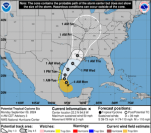
Nearly two months after Hurricane Beryl made landfall as the most recent hurricane to form in the Gulf of Mexico, forecasters are predicting another could begin affecting the coasts of Texas, Louisiana, and Mississippi as soon as Tuesday evening.
The National Hurricane Center has identified “Potential Tropical Cyclone Six” and forecast that it will become Tropical Storm Francine on Monday. Weather forecasters at the Center say the storm is expected to progress to “become a hurricane before it reaches the northwestern Gulf Coast by the middle of the week.”
“Potential Tropical Cyclone Six is expected to bring heavy rainfall and the risk of considerable flash flooding along the coast of far northeast Mexico, portions of southernmost Texas, southern Louisiana, and southern Mississippi into Thursday morning,” a press release from the National Hurricane center said. “A risk of flash and urban flooding exists across portions of the Mid-South from Wednesday into Friday morning.”

Hurricane and storm surge watches will likely be issued for a portion of the coastal area later today by the National Weather Service, with flooding risks expected to linger into Friday morning. The current track shows the storm making landfall on the mid-Gulf coast of Louisiana Wednesday, with models suggesting as much as 12 inches of rain in some areas.
Two other systems, one in the central Atlantic and the other to the east, have medium chances of forming into tropical depressions or stronger over the next week.
With just a single hurricane so far, the 2024 hurricane season has been quiet relative to what was expected to be one of the busiest in years, although some experts are predicting a stark increase in hurricane activity over the next month.
The post Forecasters expect second hurricane of 2024 season to form in Gulf of Mexico this week appeared first on SuperTalk Mississippi.


