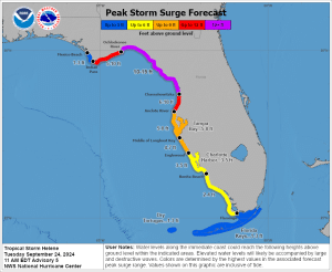
The system previously identified as Potential Tropical Storm Nine by the National Weather Service formed into Tropical Storm Helene on Tuesday. Forecasters expect the system to intensify into a hurricane as it moves through the eastern Gulf of Mexico.
The center of Tropical Storm Helene is currently located around 170 miles southeast of the western tip of Cuba. Helene’s maximum sustained winds are 45 miles per hour, with tropical storm force winds extending outward 140 miles. The storm is currently angling toward the Gulf Coast at 12 miles per hour.
Forecasting models predict that Helene will track northwest through the Yucatan Channel on Wednesday and then accelerate north-northeast towards the Big Bend region of Florida on Thursday as a major storm, possibly as high as a Category 3 hurricane.

No direct impacts of Helene are expected for coastal Mississippi, with tropical rain and wind expected to pass to the east over Florida and Alabama. However, local waters are expected to have waves 2-4 ft on Wednesday and Thursday, while local winds are expected to gust 10-20 mph on Thursday.
More northern portions of the state are also expected to sustain rainfall and potential thunderstorms as a result of Helene’s outer impacts.
The post Tropical Storm Helene forms in Gulf of Mexico, heads toward Florida appeared first on SuperTalk Mississippi.


